Busan Subway Guide: How to Ride and Route Map | Perfect for First-Timers in Busan!
If you're sightseeing in Busan, take advantage of the convenient and easy-to-use subway (Busan Metro). It connects major areas of Busan such as Nampo-dong, Seomyeon, and Haeundae, and is a recommended mode of transportation even for first-time Japanese travelers.
This time, we'll provide detailed information useful for your trip, from how to read the Busan subway map, how to buy tickets, how to use transportation cards, access to major tourist attractions, travel times, nearest exits, and how to check the last train.
The estimated travel time is for normal conditions. It may vary depending on transfers, walking, waiting times, and congestion, so please check the latest route on the official app or map app before departure.
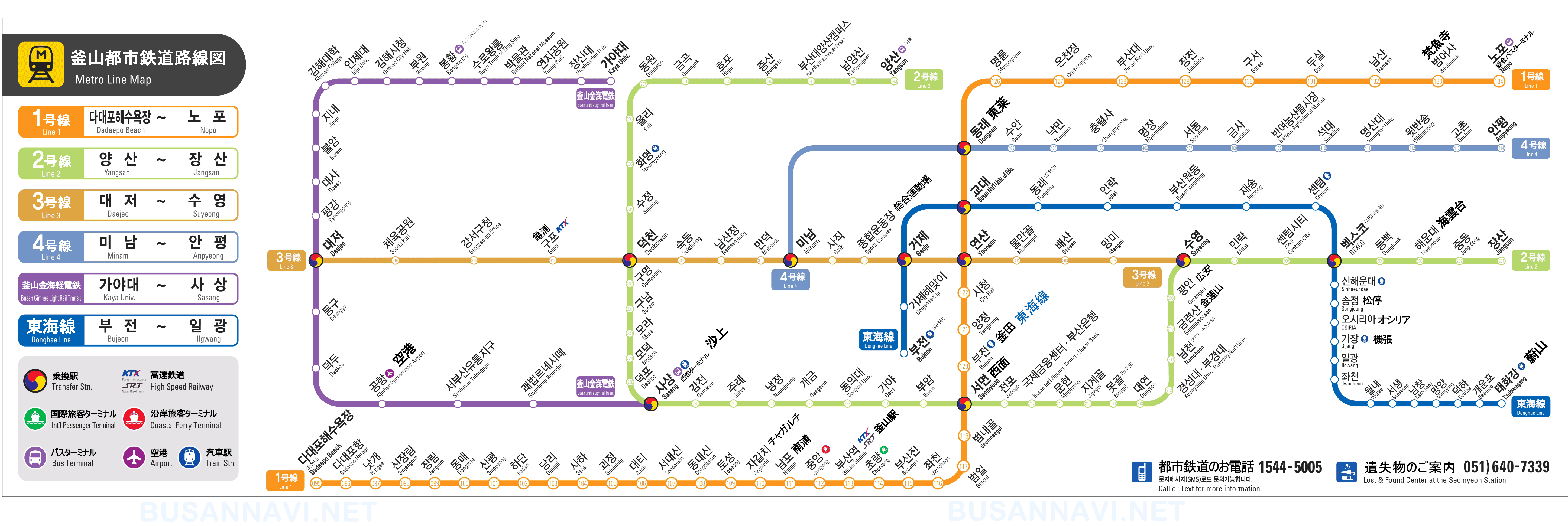
Busan subway map
Busan's subway system mainly consists of four lines: Line 1 through Line 4. Each line is color-coded, so it's helpful to refer to the route map to check the colors and station names while you're traveling.
Click here for the Busan subway route map.
Checking the route map before your trip will make it easier to understand the route to your destination and the transfer stations.
Main routes and tourist areas
| route | Major stations and tourist areas |
| Line 1 (orange) | Busan Station, Nampo, Jagalchi, Seomyeon, Oncheonjang, etc. |
| Line 2 (green) | Seomyeon, Gwangan, Haeundae, Centum City, etc. |
| Line 3 (beige) | Areas such as Suyeong, Rensan, Deokcheon, and Gupo. |
| Line 4 (blue) | Minami, Dongnae, Anpyeong area, etc. |
*Please refer to the route map above for details on station names and lines.
If you're going from Busan Station to Nampo-dong or Jagalchi Market, Line 1 is convenient. If you're going from Seomyeon to Haeundae or Gwangalli, Line 2 is more convenient. Depending on your destination, combining buses and walking can make sightseeing more efficient.
Examples of access to major tourist destinations
The following is an example of how to get to Busan's main tourist attractions by subway. The travel time is an approximate estimate including travel time and transfers, and walking time from the station to the tourist attraction may be required separately.
Nampo-dong, BIFF Square, Jagalchi Market
Example of access: Busan Station → Nampo Station
- From Busan Station, take Line 1 towards Dadaepo Beach.
- Approximately 5 minutes to Minamiura Station
- Nearest exits to Nampo Station: Exits 1, 3, and 5, etc.
- BIFF Square is about a 5-10 minute walk from Nampo Station.
- Jagalchi Market is accessible on foot from Exit 10 of Jagalchi Station or from Nampo Station.
If you plan to visit Nampo-dong's shopping district, Yongdusan Park, and Gukje Market all at once, it's convenient to use both Nampo Station and Jagalchi Station. Exit numbers may change due to renovations or changes in signage, so please check the local signs as well.
Gamcheon Culture Village
Example of access: Busan Station → Toseong Station → Bus or taxi
- From Busan Station, take Line 1 towards Dadaepo Beach.
- Approximately 10 minutes to Tsuchijo Station
- From Exit 6 of Toseong Station, transfer to a bus or taxi bound for Gamcheon Culture Village.
- Travel time including subway and transfers: Approximately 25-40 minutes
- It takes about 10-15 minutes by bus from Toseong Station to the entrance of Gamcheon Culture Village.
Gamcheon Culture Village is quite a distance and involves hills, making it difficult to reach on foot from the subway station alone. It's more common to take a bus or taxi from Toseong Station. Before you leave, please search for "Gamcheon Culture Village" or "감천문화마을" (in Korean) on a map app to find bus stops and routes.
Seomyeon
Example of access: Busan Station → Seomyeon Station
- From Busan Station, take Line 1 towards Nopo.
- Approximately 10 minutes to Seomyeon Station
- Nearest exits to Seomyeon Station: Exits 2, 4, 7, 8, etc.
- To get to the Seomyeon Underground Shopping Arcade, the restaurant area, or Lotte Department Store, choose the exit closest to your destination.
Seomyeon Station is a transfer station where lines 1 and 2 intersect. Because the station is large, it's a good idea to check not only the exit number but also the Korean signage of your destination and walking routes on a map app.
Gwangalli Beach
Example of access: Seomyeon Station → Geumnyeonsan Station or Gwangan Station
- From Seomyeon Station, take Line 2 towards Jangsan.
- Approximately 15 minutes to Geumnyeonsan Station, and approximately 17 minutes to Gwangan Station.
- From Exit 3 or 5 of Geumnyeonsan Station, walk towards the coast for about 10-15 minutes.
- From Exit 3 or 5 of Gwangan Station, walk towards the coast for about 15-20 minutes.
- Travel time from the west side: Approximately 30-40 minutes
If you want to see the Gwangandaegyo Bridge head-on, check the direction towards the coast using a map app. After enjoying the night view, it's recommended to check the last train times in advance.
Haeundae Beach
Example of access: Seomyeon Station → Haeundae Station
- From Seomyeon Station, take Line 2 towards Jangsan.
- It takes about 25-30 minutes to Haeundae Station.
- From Exit 3 or 5 of Haeundae Station, walk towards the coast for about 10-15 minutes.
- Estimated travel time from Seomyeon to Haeundae Beach: Approximately 40-50 minutes
You can walk from Haeundae Station to the beach. If you're heading to Haeundae Market or a hotel along the coast, check a map app to find the exit closest to your destination.
Haedong Yonggungsa Temple
Example of access: Haeundae Station or Songjeong Station on the Donghae Line → Bus or taxi
Haedong Yonggungsa Temple is not located right next to a subway station.
- Take a bus or taxi from Haeundae Station.
- Travel time including transfers from the subway station: Approximately 40-60 minutes
- You can also take a bus or taxi from Songjeong Station on the Tokai Line.
- It's about a 5-10 minute walk from the nearest bus stop to the entrance.
To reach Haedong Yonggungsa Temple, you'll need to combine subway travel with buses and taxis. Travel time can vary significantly depending on traffic conditions, so allow plenty of time for your journey.
Centum City / Shinsekai Centum City
Example of access: Seomyeon Station → Centum City Station
- From Seomyeon Station, take Line 2 towards Jangsan.
- Approximately 20-25 minutes to Centum City Station
- Access to Shinsegae Centum City from exits 12, 13, and 14 of Centum City Station.
- Travel time from the west side: Approximately 30-40 minutes
Shinsegae Centum City, BEXCO, and the Cinema Center are all within walking distance of Centum City Station or the Museum of Fine Arts Station. Since the nearest station and exit vary depending on the facility, please search for your destination individually.
Songdo Marine Cable Car
Access example: Nampo Station or Jagalchi Station → Bus or taxi
The Songdo Marine Cable Car is too far to reach on foot from the subway station.
- Take a bus or taxi from Nampo Station or Jagalchi Station.
- Travel time from the subway station, including transfers: Approximately 20-35 minutes
- Search for "Songdo Bay Station" or "송도베이스테이션" (in Korean) as your destination.
Please check the official website or map app for the latest information, as service status and boarding locations may change.
Taejongdae
Example of access: Minamiura Station → Bus or taxi
- Take a bus or taxi from Nampo Station.
- It takes approximately 30-50 minutes from Nampo Station to Taejongdae Entrance.
- Travel time including subway and bus transfers: Approximately 45-70 minutes
Since Taejongdae is far from the subway station, taking the bus is the primary mode of transportation. While sightseeing trains may be available for getting around within the park, be sure to check their operating status and hours in advance.
How to ride the Busan subway
1. Prepare your transportation card.
In Busan, using a transportation card such as T-money makes riding the subway and buses much smoother. You can purchase and top up these cards at convenience stores or by following the signs at the station.
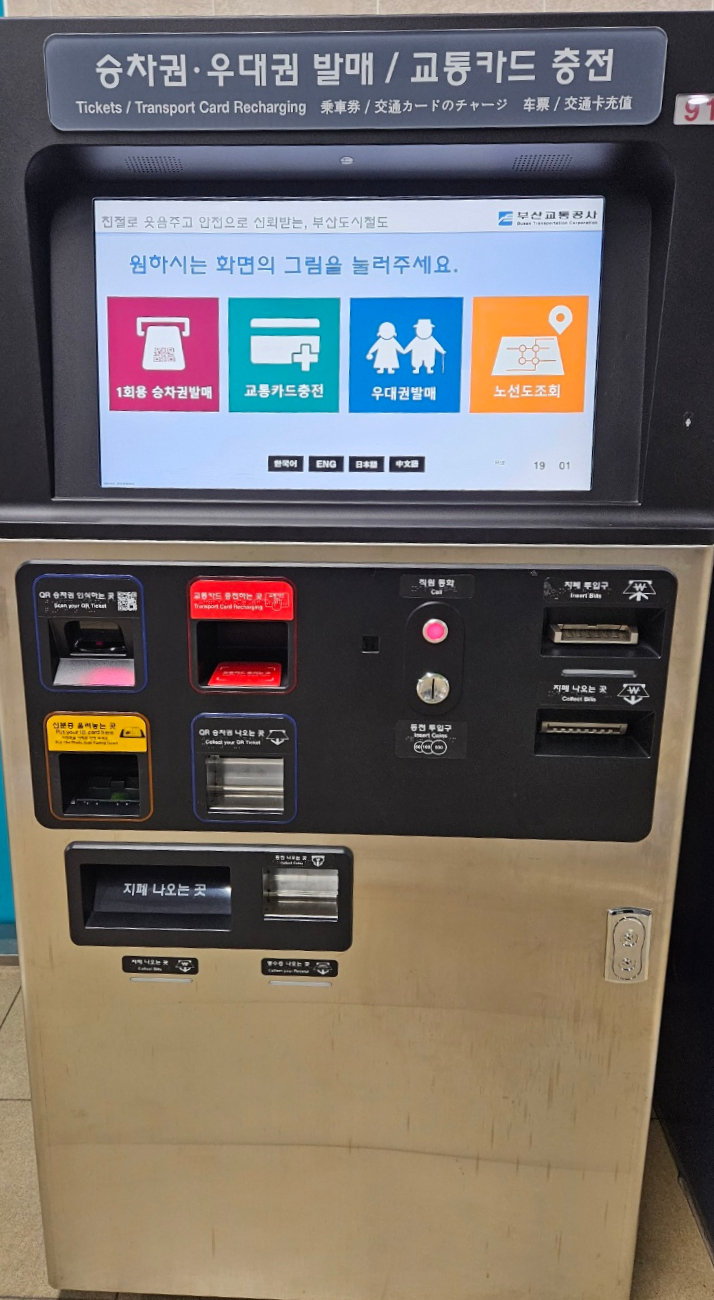
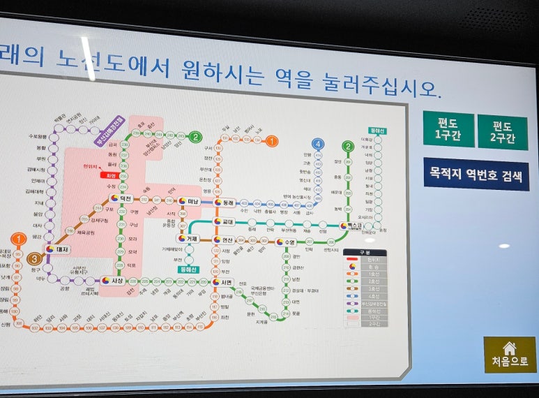
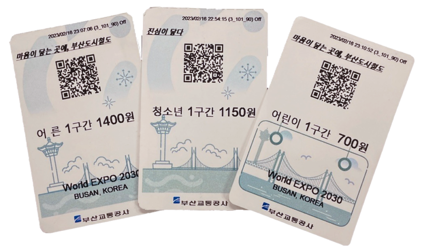
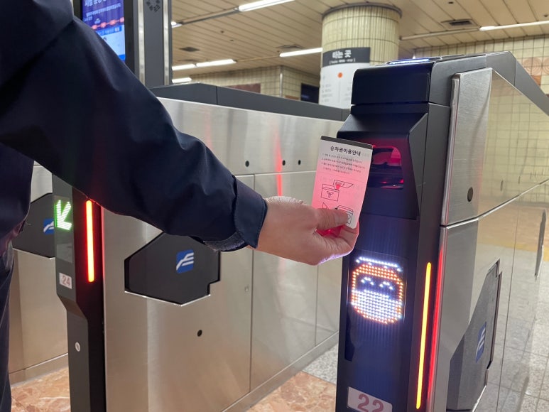
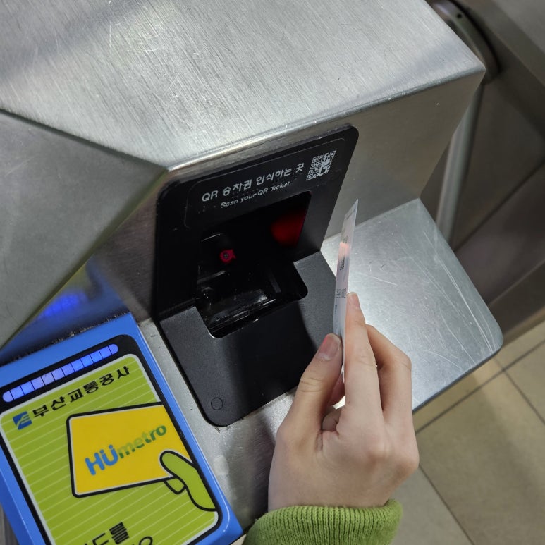
If you don't have a transportation card, you can also purchase a one-time QR code ticket at a ticket machine at the station .

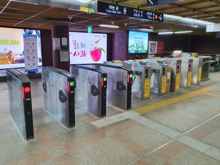
2. Go through the ticket gate.
If using a transportation card, touch the card to the reader on the ticket gate. If using a QR code ticket, hold the QR code over the corresponding reader to enter.
Even if you don't understand Korean, you can operate the ticket gates and ticket machines by checking the displays.
3. Confirm your destination and direction of travel.
At the station, be sure to check not only the name of your destination station but also the direction the train is traveling.
For example, if you are going from Seomyeon Station to Haeundae Station, take Line 2 bound for Haeundae. Please check the platform signs to make sure you don't take the wrong train.
In addition to Korean, the station also has signs in English and other languages.
4. Get off at your destination station.
Once you arrive at your destination station, get off the train, check the exit number, and head to the ticket gate. Some tourist destinations have multiple exits, so it's helpful to check in advance using a map app to find the exit closest to your destination.
If you are using a transportation card, please tap the card again when you exit. If you are using a ticket, please follow the instructions to pass through the ticket gate.
Transportation cards and fares
Busan subway fares are divided into two zones, 1 zone and 2 zone, depending on the distance traveled.
The following are the basic adult fares as confirmed on the Busan Transportation Corporation's official fare guide. Please note that the official website may contain information on fare revision dates, so be sure to check the latest information before traveling.
| Classification | Transportation Card | QR ticket |
| 1 section | 1,600woon | 1,700woon |
| 2 section | 1,800woon | 1,900woon |
*The above fare information is based on what can be found on the official website. Fares, ticket types, and conditions for using transportation cards are subject to change. Please check the latest information on the Busan Transportation Corporation's official fare guide before publication or before traveling.
Transportation cards are convenient for sightseeing, especially when combining subway and bus travel, as they eliminate the hassle of purchasing tickets each time you ride.
Official fare information:
https://work.humetro.busan.kr/homepage/default/page/subLocation.do?menu_no=1001010501
Subway and bus transfers
In Busan, you can use a transportation card to transfer between the subway and buses. Transfer discounts apply when you meet the applicable transportation requirements and conditions.
When transferring trains, please keep the following points in mind.
- You need to tap your transportation card both when boarding and when alighting.
- Even when transferring from a bus to the subway, don't forget to tap your card when you get off.
- Check the discount eligibility requirements, such as transfer time and eligible routes.
- When visiting tourist attractions far from subway stations, be sure to check the walking time after transfers.
If you pay cash for your bus fare, you won't be eligible for the transfer discount offered with transportation cards, so using a transportation card is recommended.
How to check the last train
The last subway train times vary depending on the line, station, day of the week, and destination. Even at the same station, the time of the last train changes depending on the direction you're going, so don't assume that "the last train is at this station" as a whole. Instead, specify your boarding station, alighting station, and direction of travel to check.
Check the Busan Transportation Corporation's official website.
You can check route maps, station information, and service information on the Busan Transportation Corporation's official website.
- Open the Busan Transportation Corporation's official website.
- Select a route map or station search.
- Specify your boarding station and alighting station.
- Check the direction of travel and the time of the last train.
- If you have to transfer trains, check if you can make it to the last train at your destination.
Official site:
https://www.humetro.busan.kr/
If the website is displayed in Korean, it is helpful to use your browser's translation function. Please note that menu names and displays on the official website may change, so please check the latest information using the station name search or route map.
Check using the official app or map app.
The following apps and search methods are convenient on smartphones.
- Busan Metro (Official and authorized app for the Busan subway system)Route maps, station information, and transfer searches may be available. Please check the source and update date before use.
- NAVER MapThis is a convenient tool for searching for subway, bus, and walking routes within South Korea. Entering station names or tourist destination names in Korean will yield more accurate results.
- KakaoMapThis is useful for checking routes combining subway and bus, travel time, and walking routes.
- Google MapsWhile it can be used to locate tourist attractions, in South Korea, public transportation search results can vary depending on the service and region, so it's best to use it in conjunction with NAVER Map or KakaoMap.
Search example:
- "Busan Station, Haeundae Station, Subway"
- "I want to know"
- "Last train from Seomyeon Station to Haeundae Station"
- "I want to know"
- "Gamcheon Culture Village Toseong Station Bus"
- "I'm happy"
The times displayed in the search results may vary depending on weekdays, Saturdays, holidays, temporary schedules, construction, etc. Please check the official information from Busan Transportation Corporation or the signs within the station for the most up-to-date information.
Points to note when checking the last train
- Check the last train departing from your departure station, not the time you arrive at your destination.
- Upon arriving at the transfer station, check if the last train on the next line has already departed.
- Take into account the walking time to the station and the time it takes to get to the ticket gate.
- Allow at least 20-30 minutes to spare, including time to return to the station from the tourist spot.
- Prepare a taxi-hailing app and the address of your accommodation in case you miss the last train.
In particular, areas like Haeundae, Gwangalli, Gamcheon Culture Village, and Songdo can take a long time to reach the subway station from the tourist spots. If you plan to enjoy the night views or night markets, be sure to check your return route in advance.
Useful tips for travelers
Seomyeon Station is convenient for transfers.
Seomyeon Station is a major station where lines 1 and 2 intersect. It can be used as a transfer hub when traveling from Nampo-dong to Haeundae, for example.
Also check the Korean spelling of the station name.
Busan's train stations use signs in Korean, English, and other languages. Registering the Korean name of your destination in your smartphone's map app will make it easier to identify the station.
The main Korean terms are as follows:
| Japanese | Korean |
| Busan Station | Busan Station |
| Seomyeon Station | Home |
| Minamiura Station | Home page |
| Jagalchi Station | Sorry for the inconvenience |
| Haeundae Station | Home |
| Gwang'an Station | 광안역 |
| Kinrensan Station | Sorry to bother you |
| Centum City Station | Centum City Station |
| Tsuchijo Station | homepage |
Search again for the nearest exit using the destination name.
Even within the same tourist area, the best exit varies depending on whether you're looking for a hotel, shopping center, market, or beach. It's helpful to search not only by station name, but also by combining your destination name with "exit" or the Korean word "출구" (exit).
Example:
- "Haeundae Beach, Haeundae Station, which exit?"
- "I want to know"
- "BIFF Square, Nampo Station Exit"
- ``BIFF 광장 남포역 출구''
Exit numbers may change due to construction, facility entrance changes, station signage changes, etc. Please check both the on-site signs and the walking route on your map app.
Check the time of the last train.
Subway operating hours vary depending on the line, station, and day of the week. If you plan to enjoy sightseeing or dining late into the night, be sure to check the return train schedule in advance.
Some tourist destinations are difficult to reach by subway alone.
Some tourist spots are located along the coast or in mountainous areas, and are quite far from train stations. Depending on your destination, combining local buses, taxis, and private cars can be a convenient way to get around.
Allow extra time for transfers.
At large stations like Seomyeon Station, travel between lines and walking to the exit can take time. For routes involving transfers, it's a good idea to allow an extra 10-15 minutes on top of the estimated travel time shown in the search results.
Summary
The Busan subway is a convenient mode of transportation for getting around major tourist areas. Checking the route map to find your destination and transfer stations, and having a transportation card ready, will make it easy to use even for first-time visitors to Busan.
For Nampo-dong and Jagalchi Market, Nampo Station and Jagalchi Station on Line 1 are convenient. For Seomyeon, Seomyeon Station on Lines 1 and 2 is convenient. For Gwangalli and Haeundae, Geumnyeonsan Station, Gwangalli Station, and Haeundae Station on Line 2 are convenient. On the other hand, for Gamcheon Culture Village, Haedong Yonggungsa Temple, Taejongdae, and Songdo, you may need to transfer from the subway to a bus or taxi.
Fares, travel times, nearest exits, and last train times are subject to change, so please check the latest information on the Busan Transportation Corporation's official website, NAVER Map, KakaoMap, etc., before and on the day of your trip.
Before your trip, it's a good idea to check the Busan subway map to find out the best route, transfer stations, nearest exits, and the last train back that suits your travel plans.
Click here for the Busan subway route map.
BusanNavi provides useful information for Japanese travelers, including Busan's tourist attractions, restaurants, hotels, and transportation. Please use it to help plan your trip to Busan.
Basic Information
| Item | Message |
| Transportation | Busan Metro (Subway) |
| Main routes | Line 1, Line 2, Line 3, Line 4 |
| How to ride | Transportation card or QR code ticket |
| Fare | Adults: 1,600 won for one section, 1,800 won for two sections (when using a transportation card) *Please check the official website for the latest information. |
| Route Map | https://www.busannavi.net/busan-map/busan_subway/ |
| Official Website | https://www.humetro.busan.kr/ |
| Route search | NAVER Map, KakaoMap, Busan Transportation Corporation official website |
| Check the last train schedule | Busan Transportation Corporation official website, official app, station signage |
*Fares, service information, travel time, nearest exit, and last train times are subject to change. Please check the Busan Transportation Corporation's official website or app for the latest fares, fare revision dates, ticket types, terms of use, and service status.
Busan subway map